The goal of this workshop is described as addressing position relevant data as metadata in lightweight position-dependent applications, such as tourist applications. Such a metadata should be required as one of the indispensable attributes of various existences such as human, things, buildings, and geographic features. To realize the position relevant metadata, we should consider at least three points of view:
| (a) | applications using metadata on one location; and |
| (b) | applications using metadata on plural locations such as a start point, via points, and a goal point (in other words, a destination). |
Aiming to realize various application of the (b) including the (a) as a special case, we proposed the "NaVigation Markup Language (NVML)" [1]. We think that the problem of the position relevant metadata should be investigated considering the applications such as the (a) and the (b). For this sake, we would like to introduce the specification and applications of the NVML briefly.
A variety of mobile information appliances are developed rapidly such as smart phones with capability of Internet access, PDAs (Personal Digital Assistants) equipped with GPS (Global Positioning System), and car navigation systems. A navigation service is one of the indispensable services to these mobile information appliances, but currently it is only available with car navigation systems. In order to use the navigation service not only on cars but also on trains, on buses, and during walking with various mobile information appliances, a common data format for describing navigation information such as locations of points and route information is required.
The "NVML" (NaVigation Markup Language) [1] is a markup language for describing the navigation information satisfying the above requirement, and is defined by using the XML (eXtensible Markup Language) [2] authorized by the W3C. Since the contents of NVML data (e.g., Kyoto-Nara Tour) are marked up by tags (e.g., <title>), anyone can understand the data easily and computers can process and search the data quickly. Besides, NVML has a capability to describe several types of navigation information such as:
Figure 1 shows a navigation data described by using the NVML.
<nvml version = "0.60">

    <head>
        <title>     Rainbow Town Tour </title>
        <category>  sightseeing       </category>
        <transport> car, foot         </transport>
        <duration>  3 hours           </duration>
        <distance>  9.6km             </distance>
        <expense>   700 yen           </expense>
    </head>

    <body>
        <navi>
            <point>
                <name>      Tokyo Station     </name>
                <category>  Station           </category>
                <latitude>  N35.40.39.0       </latitude>
                <longitude> E139.46.18.1      </longitude>
                <address>   Chiyoda-ku, Tokyo </address>
            </point>
            <info delay = "2s" duration = "5s">
                <text>
                    Tokyo Station
                </text>
                <voice>
                    This is Tokyo Station.
                </voice>
                <image src = "image/tokyo-station.jpg"/>
            </info>
        </navi>

        <navi>
            <route>
                <means> car </means>
            </route>
        </navi>

          ...

        <guide>
            <point>
                <name>      Odaiba Seaside Park </name>
                <category>  Park                </category>
                <latitude>  N35.37.39.6         </latitude>
                <longitude> E139.46.54.5        </longitude>
            </point>
            <info duration = "10s" area ="5km">
                <voice>
                    You can see the beautiful Rainbow Bridge.
                </voice>
                <image src = "image/odaiba.jpg"/>
            </info>
        </guide>

          ...

    </body>

</nvml>
|
The meaning of each element is as follows:
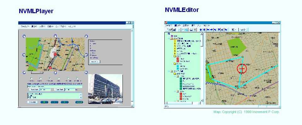
(1) NVMLPlayer
We are developing an NVML tool called "NVMLPlayer" which plays NVML data and has following functionalities:
| - | display of the point and route on a map and output of the navigation/guidance information by texts, voices, and images; and |
| - | actual navigation and virtual simulation of the courses. |
(2) NVMLEditor
We are also developing an NVML tool called "NVMLEditor" which is for editing and authoring NVML data and has following functionalities:
| - | display of the NVML data as a tree structure with GUI (Graphical User Interface); |
| - | indication of the points on a map; and |
| - | creation of the navigation/guidance information by texts, voices, and images. |
Figure 2 shows an NVMLPlayer and an NVMLEditor for PCs. The NVMLPlayer is implemented as a plug-in software for popular web browsers.
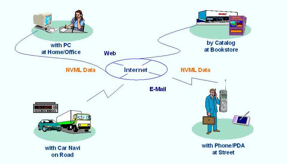
The popularization of the NVML will lead to various applications:
Figure 3 shows these applications of the NVML.
Our suggestion is that the problem of the position relevant metadata should be investigated considering the applications using metadata on plural locations (including one location as a special case) such as a start point, via points, and a goal point (in other words, a point of interest). For this sake, we explained the specification and applications of the NVML briefly.
Realization of the NVML has also three issues:
| - |
Output the navigation/guidance information of points and routes by texts, voices, and images with
|
||||
| - |
Look at the navigation/guidance information of texts and images with
|
||||
| - |
Look at the navigation/guidance information of texts, images, and simple maps with
|
Thus the NVML is a good example of an application of the W3C and the WAP technologies and the considerations on the NVML will contribute to the W3C and the WAP technologies. Finally Our expectation is that the working group, which will be organized depending on the result of this workshop, will treat the position relevant information considering the functionalities of navigation/guidance such as shown by the NVML.
Our suggestion is that the problem of the position relevant metadata should be investigated considering the applications using metadata on plural locations (including one location as a special case) such as a start point, via points, and a goal point (in other words, a point of interest). For this sake, we would like to explain the specification and applications of the NVML briefly.
The "NVML" (NaVigation Markup Language) [1] is a markup language for describing the navigation information such as locations of points and route information. The NVML enables us to use a navigation service at any time and anywhere, and it will also be used in other services such as a guide service for sightseeing, a travel planning service, and a publishing service for tourists.
| [1] | "NaVigation Markup Language (NVML)," World Wide Web Consortium (W3C) Note, 6 Aug. 1999, http://www.w3.org/TR/1999/NOTE-NVML-19990806 . |
| [2] | "Extensible Markup Language (XML) 1.0," World Wide Web Consortium (W3C) Recommendation, REC-xml-19980210, 2 Feb. 1998. http://www.w3.org/TR/1998/REC-xml-19980210 . |
| [3] | "Synchronized Multimedia Integration Language (SMIL) 1.0 Specification," World Wide Web Consortium (W3C) Recommendation, REC-smil-19980615, 15 Jun. 1998, http://www.w3.org/TR/1998/REC-smil-19980615 . |
| [4] | "Compact HTML for Small Information Appliances," World Wide Web Consortium (W3C) Note, 9 Feb. 1998, http://www.w3.org/TR/1998/NOTE-compactHTML-19980209 . |
| [5] | "Wireless Markup Language Specification," Wireless Application Protocol (WAP) 1.0 Specification Suite, wml-30-apr-98.pdf, http://www.wapforum.org/what/technical_1_0.htm . |
| [6] | "XHTML 1.0: The Extensible HyperText Markup Language - A Reformulation of HTML 4.0 in XML 1.0," World Wide Web Consortium (W3C) Proposed Recommendation, PR-xhtml1-19991210, 10 Dec. 1999, http://www.w3.org/TR/1999/PR-xhtml1-19991210 . |
| [7] | "Scalable Vector Graphics (SVG) 1.0 Specification," World Wide Web Consortium (W3C) Working Draft WD-SVG-19991203, 3 Dec. 1999, http://www.w3.org/TR/1999/WD-SVG-19991203 . |