Warning:
This wiki has been archived and is now read-only.
SSN Uni deployment
University deployment example
Available resources
- OWL file: uni-deploy.
- Paper: [Barnaghi and Presser 2010], Publishing Linked Sensor Data.
Sensor descriptions, sensor deployment platforms, and operational and survival conditions can be related to other spatial, temporal and thematic data. Figure 5.28 demonstrates this in the context of the SENSEI project. In this work the sensor platform descriptions are associated to location data obtained from open linked-data (i.e. in particular by querying DBPedia SPARQL end-points). The sensor platform and location data are then used to demonstrate sensor information on an overlay Google Map mash-up application.
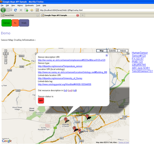
Figure 5.28 - University deployment example: sensor data mashup
The sensor platform location data in this example is defined as linked-data location information and is also associated to local location ontology descriptions. This enables navigation through a set of linked sensor data and querying sensors based on their deployment and other attributes as well as their physical locations. (For more information refer to: [Barnaghi and Presser 2010]).
The following figures provide an overview of the modules of the SSN ontology which are illustrated by this example.
The OWL file of the example is also available: [uni-deploy]
Deployment
Figure 5.29 illustrates how the Deployment, System, Platform, OperatingPowerrange and SensingDevice classes are used. More information about this part of the example is available on Deployment module documentation page.
Figure 5.29 - University example - Deployment
Sensor
Figure 5.30 shows how Measuring Capabilities are defined. For more information, see the documentation pages for the MeasuringCapability module and the Condition module.
Figure 5.30 - University example - Sensors