Introduction
The CEO-LD project sought to foster UK-China relations in the field of satellite imagery, treating such images as sources of data that can be processed by computers rather than images for human inspection and interpretation. The aim was to provide experience from both countries that would support the collaboration between the OGC, the standards body for geospatial information systems, and W3C, the standards body for the Web. The project can certainly claim success in the latter in that work now being carried out in that formal standards-setting Working Group has been very substantially led by work exposed through the CEO-LD project. However, it must be acknowledged that the UK-China collaboration has been less substantial than hoped for.
CoverageJSON
A key point of reference has been the work done at the University of Reading under the EU MELODIES project funded by the EU’s Seventh Framework Programme. The CoverageJSON specification, developed by Maik Riechert and Jon Blower, was discussed in detail at both the London and Beijing meetings of CEO-LD and now forms the basis of one of the outputs of the W3C/OGC Working Group. It is very unlikely that the CoverageJSON work would have come to the attention of the Working Group without the CEO-LD project, still less that it would be on its way to being a joint OGC/W3C publication.
The Chinese Contribution
The project’s second meeting, held in Beijing on 28 February 2016, provided a much needed route to validation of the CoverageJSON approach by engineers not associated with the MELODIES project. Following the meeting, CNIC reported no problem converting a GeoTIFF image into CoverageJSON and then exposing that on the Web (GeoTIFF is the standard format for high resolution satellite images that includes location metadata). In doing so, CNIC showed that satellite data containing many bands (measurements) can be rendered as a set of minified and compressed CoverageJSON resources.
It was possible for the Reading team to make use of those CoverageJSON resources directly without having to write a custom API, meaning that the native linking functionality within the data format was successfully exploited. Furthermore, it was easy to write demonstrations around that like an interactive visualisation of the client-side NDVI derivation based on two satellite bands that were then loaded on-demand in the browser. The screenshots below are of that Chinese data displayed in the UK tool.
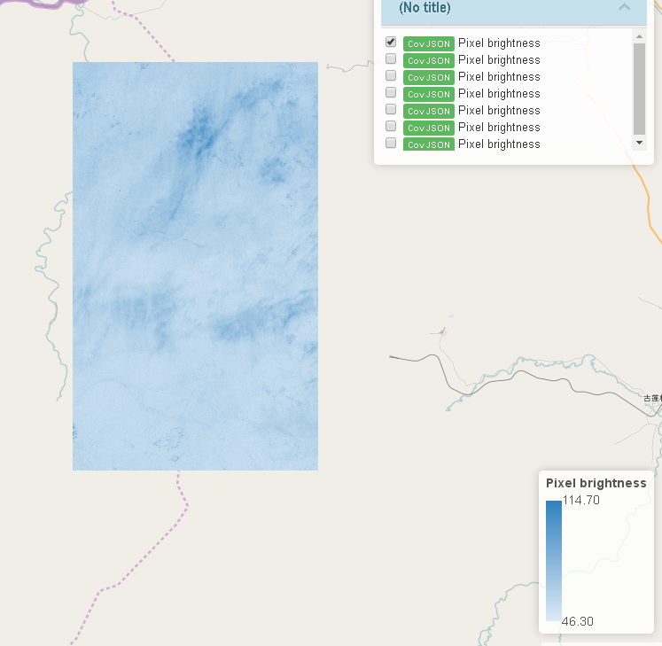
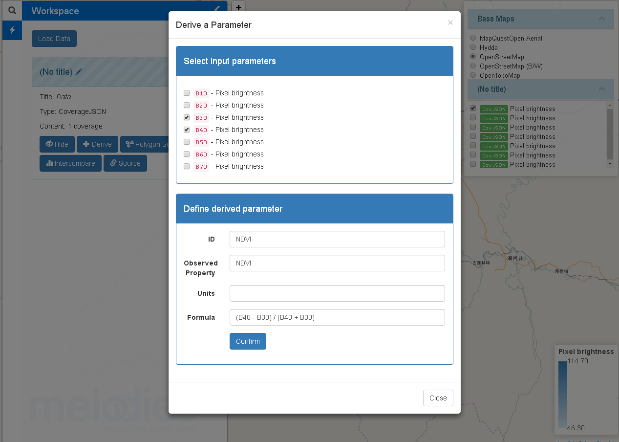
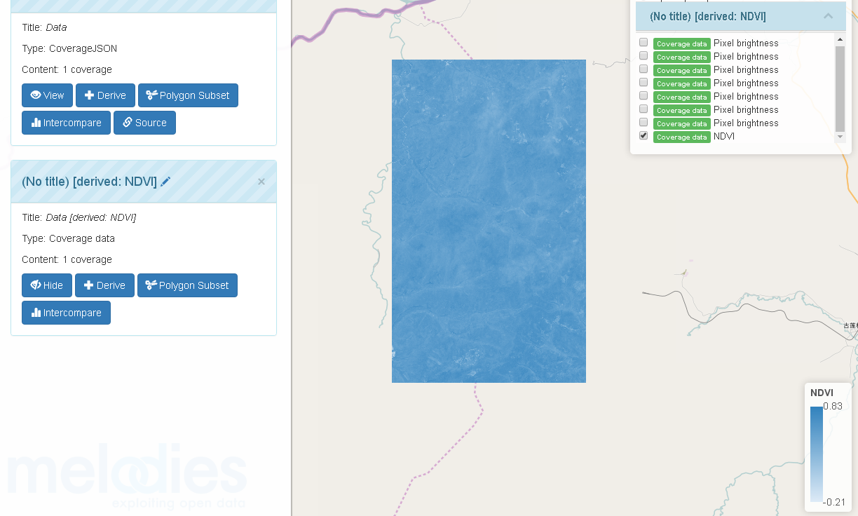
Unfortunately, CNIC didn’t provide any further explanation of the data other than ‘pixel brightness’ so that it’s not clear which spectral bands are represented. It is also difficult to convey in screenshots the central important fact: that the satellite image is being processed within the Web browser as data and not as an image. Therefore, it could be mixed with other information and manipulated to provide deeper insights.
Subsets
A topic discussed at both the London and Beijing meetings was that of subsets, that is, identifying and accessing small, manageable chunks of large datasets. This is particularly relevant in the field of satellite-derived data where the data volumes can be enormous. After the Beijing meeting, the University of Reading experimented with dynamic subsetting using the Hydra ontology developed informally at W3C. This proved to be too complicated for practical use in the current context and so CoverageJSON was extended to include range-tiling capabilities, allowing applications to request data one tile at a time. This is in line with standard practice in the geospatial world where online maps are typically served as a set of tiles that are then displayed seamlessly in the browser.
Describing a fixed set of URL-template-based tile sets means that even big coverage data can be accessed in small manageable chunks while making sure that those chunks are cacheable and may even be pre-generated and hosted as static resources, providing a scalable and simple way of hosting bigger Web-friendly Coverage data. Integrating this into the format itself means there is a single recommended way to build a trivial API for requesting subsets, providing strong guidance for data publishers and also data users.
The OGC/W3C Standard
OGC and W3C’s Spatial Data on the Web Working Group has split itself into a number of subgroups in order to carry out its various tasks, with the work on Coverages being led by Bill Roberts of Swirrl who took part in the Beijing meeting. It is noteworthy that the CoverageJSON approach is not favoured by all members of the WG. In particular, a team from the Australian National University is working on a solution based on an existing W3C standard for expressing statistical data (the RDF Data Cube). Both approaches show promise; however, their proponents do not feel that their work is sufficiently well developed to warrant full standardisation. The WG is therefore going to publish both approaches separately as working group outputs but not as formal standards (in OGC terms they will be Discussion Papers, in W3C they will be Working Group Notes). These provide stable documents, formally published by both standards bodies, that can be referenced and built upon in future. This should be seen as a positive outcome of the project although clearly CEO-LD has not achieved the hoped for level of UK-China engagement that would be required for either of the approaches under consideration being taken through to full standard. The two documents under development are CoverageJSON and Publishing and Using Earth Observation Data with the RDF Data Cube and the Discrete Global Grid System.
Summary
The CEO-LD project supported meetings in London and Beijing at which a variety of stakeholders were able to discuss common problems around the topic of sharing satellite imagery as data on the Web. The discussions were very valuable in that stakeholders in the field of Earth Observation from both countries were brought together to inform the W3C/OGC collaboration. These were Surrey Satellite Technology, the Satellite Applications Catapult, the Met Office, the Chinese Academy of Sciences’ Institute of Remote Sensing and Digital Earth and its Computer Network Information Center. The meetings provided a forum in which experts from both countries were able to share their experiences. The work done by CNIC shortly after the Beijing meeting validated the approach devised in Reading.
Handling Earth Observation data as a Coverage is not new, however, exposing that Coverage as data on the Web is new and, as the dual approach being taken in the Working Group shows, still very much at the experimental stage. The CEO-LD project has been instrumental in moving that discussion forward towards a time when users will be able to explore, mix and manipulate EO data flexibly in the Web browser in ways that, if they’re possible at all, currently requires specialist software.