MOGID : Mobile Geo-depended Information on Demand
| Peter Balsiger, Dequn Sun, Manuel Gomez, Fausto Pellandini | Marcel Aeschlimann+, Christophe Dworzak+ Michael Hubmann++, Alex Sollberger++ |
| Institute
of Microtechology Rue Breguet 2, CH-2000 Neuchâtel, Switzerland phone +41-32-718.34.04, fax 41-32-718-34-02 info: peter.balsiger@imt.unine.ch, web: www-imt.unine.ch/mogid |
+ Creaholic SA, Rue Molz 10, 2502 Biel/Bienne,
web: www.creaholic.com or www.mogid.com
++ Kümmerly+Frey, CH-3052 Zollikofen-Bern, web www.kuemmerly-frey.ch or www.kissswiss.com |
Position paper published at: "Workshop on Position Dependent Information Services"
Joint W3C-WAP Forum Workshop, Sophia Antipolis, February 2-3th, 2000, France
1. Introduction
2. Geo-dependent Services
Access
3. Location Technology
4. Implementation
5. Conclusion
This paper outlines possible areas of cooperation between the WAP Forum, the World Wide Web Consortium (W3C) and the mobile terminal provider and Value Added Service (VAS) providers. The WAP Forum is dedicated to enabling advanced services and applications on mobile wireless devices, such as cellular telephones. The W3C is dedicated to leading and advancing the development of the World Wide Web. This document describes the MOGID solution of mobile access to efficient information seeking. MOGID is a GSM based positioning system built inside the GSM standard and share goals for the future of the global information space. MOGID avoids unnecessary divergence between the recommendations and standards of the GSM standard and the WAP and W3C organizations. Future development occur in the areas of Intelligent Value Added Services (iVAS) based on WAP and W3C standards by the combination of user location information. MOGID fits in this direction.
The possibilities for application of cellular phones become more and more
comprehensive. All around the globe, resourceful technicians and potent
telecommunication enterprises look for still more refined applications by menas
of cellular phone. What was the product of an overenthusiastic imagination only
a few months ago has become a reality now. With MOGID - Mobile Geo Information
on Demand, the Swiss enterprises Kümmerly+Frey AG and Creaholic SA in
collaboration with the renowned Institute of Microtechnology (IMT) in Neuchâtel
have created a revolutionary invention: each cellular phone now turns into a
multipurpose orientation and information tool. On the one hand, MOGID has the
great advantage of topicality of the data available; on the other hand, there is
its functionality in cities, buildings and vehicles, and the receiving and
sending of individual information that is suited to the user (bi-directional
system). The world premiere took place at Telecom'99 in Geneva. The MOGID technology is protected worldwide by a
comprehensive patent rights strategy. Concrete talks with foreign and national 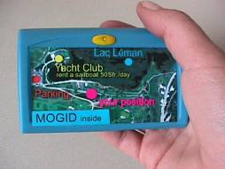 network operating authorities and value added service provider is taking place
now. The project is supported by the Kommission Technologie und Innovation (KTI)
of the Swiss Federation.
network operating authorities and value added service provider is taking place
now. The project is supported by the Kommission Technologie und Innovation (KTI)
of the Swiss Federation.
The heart of MOGID is the »locator,« operating on the basis of the GSM
cellular net. The cellular GSM phone receives a signal by the nearest GSM
antennae and uses its intelligent software and algorithms in order to calculate
the location, a calculation which is based on these GSM antennae. 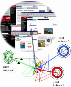 This
presents completely new possibilities to the user. MOGID works in areas where
GPS (Global Positioning System) fails (e.g. in cities where eye contact is
necessary), and provides a positioning. Once the system has calculated the
position, it connects to a MOGID server. The MOGID server provides the user
by the information that is related to its position, e.g., banks, Hotels, public
transports or any value added services that can be imagined. the display shows a
map indicating the position of the user. Different kinds of information of the
surroundings can be retrieved according to the user's needs, for instance street
names, railway stations, parks, movie theatres and even restaurants. All that
information is called up from a database which is updated constantly. Moreover,
MOGID is compatible with every database of georeferential information worldwide.
Additional information about every object can be retrieved and displayed. The
user chooses for example a restaurant; the system provides the address, the
opening hours etc. Or he chooses a means of public transport; the system
displays the nearest railway station or bus stop and organizes the timetable
according to the user's need, time and position. This system makes MOGID unique.
However, this is merely the beginning
This
presents completely new possibilities to the user. MOGID works in areas where
GPS (Global Positioning System) fails (e.g. in cities where eye contact is
necessary), and provides a positioning. Once the system has calculated the
position, it connects to a MOGID server. The MOGID server provides the user
by the information that is related to its position, e.g., banks, Hotels, public
transports or any value added services that can be imagined. the display shows a
map indicating the position of the user. Different kinds of information of the
surroundings can be retrieved according to the user's needs, for instance street
names, railway stations, parks, movie theatres and even restaurants. All that
information is called up from a database which is updated constantly. Moreover,
MOGID is compatible with every database of georeferential information worldwide.
Additional information about every object can be retrieved and displayed. The
user chooses for example a restaurant; the system provides the address, the
opening hours etc. Or he chooses a means of public transport; the system
displays the nearest railway station or bus stop and organizes the timetable
according to the user's need, time and position. This system makes MOGID unique.
However, this is merely the beginning
While standardized technology allows mobile devices to determine their position with an high accuracy of some meters (using the most fine-grained techniques), how to determine which information is relevant in that position is as yet un-standardized. Position information is also controversial, in that it can both be used for significant violations of the users privacy, and significant assistance in situations where the user can not request assistance (e.g. in a medical emergency). While privacy protection for cases where the position information is used as an entity in itself are foreseen in the standards for mobile systems, privacy protection for cases where the position is used to retrieve customized information is not.
MOGID addresses position relevant data as metadata in lightweight position-dependent applications, such as tourist applications. MOGID found a method for event and position notification that could be standardized, with the intent of arriving at a minimum set that can be brought forward as standard. The problem of position relevance of information is at once a mobile device problem and a metadata problem.
Let's have a look first at the mobile device problem:
The location of the device profile is sent with a request of a modem connection to the MOGID server or a direct Internet connection is established. As soon as the modem connection is established, a web browser or WAP browser is launched. The mobile device sends a request to the MOGID server:
(example; http://geo.mogid.com/index.html?lon=xxx&lat=yyy&area=zzz&prof=www&id=ppp.)
The theory is that, when a device makes a request using variables such as:
lon= states for longitude position
lat= for latitude position
area= stands for area of user location
prof= stands for the user preferences and profile
id= stands for user identification password.
Let's have a look now at the MOGID server problem:
How can a device tell the server about its capabilities. The question is, given the needs of the various devices accessing the MOGID server, how can the server know about the capabilities of individual devices? How can it know that a mobile phone with a very small screen is requesting a Web page, rather than a pocket-sized computer asking for the same information? The current implementation is to store data about each device - and also the preferences of its user - as a device profile. The device profiles would be stored as a kind of relational database located on a MOGID server. A Preference Profile is a collection of information which describes the capabilities, hardware, system software and applications used by someone accessing the MOGID server, as well as the particular preferences of the users themselves. Information might include the preferred language, sound on/off, images on/off, class of device (phone, PC, printer, etc.), screen size, available bandwidth, version of HTML supported, and so on.
The MOGID server decodes the request and decodes the variables. In the case of a mobile phone, not only would the phone send request a URL in the usual way, but it would also send a set of variables in the form of a second URL to indicate where its device profile could be found. The critical piece in the puzzle is that the URL "variables" goes straight to the MOGID database. The server script is written in XML language for modeling metadata - descriptive information about items on the Web. The whole point is that information encoded is always linked to Web addresses. What this means is that by sending a URL for the device profile, that all kinds of data about that device immediately becomes available. This can be in a certain extend protected by a security mode access by means of encrypting and decrypting the information. The same critical point is the access of such value added services. Is is basically a service that is not for free thus user must login in the MOGID system in order to get enabled the corresponding services purchased in advanced or played end each month.
The prof variable could include information such as:
preferred language
sound on/off
images on/off
privacy preferences (like P3P)
scripting on/off
cookies on/off
etc.
Also want to assert hardware platform attributes, like:
vendor
model
class of device {phone, pda, printer, etc.}
screen size
colors
available bandwidth
CPU
memory
input device
secondary storage
loudspeaker
etc.
We also expect them to want to assert software defined variables, such as:
application brand and version
level of HTML support
supported XML vocabularies
Level of CSS support
supported RDF vocabularies
level of WAP support
supported scripting languages(s)
etc.
Today two fundamentally different system architectures allows localization of cellular GSM phones. The first one is the so called Network-Based localization system and the second is the Handset-Based localization system. The US Requirements (ETSI is following) for emergency calls are:
| Network-Based | Prior Phase II Requirements | New Phase II Requirements |
| Implementation | Within the later of 6 months after PSAP request or Oct. 1, 2001 | Within the later of 6 months after PSAP request or Oct. 1, 2001 deploy to 50% of callers and to 100% off callers 1 year later |
| Accuracy | 125 meters RMS | 100 meters 67 % 300 meters 95 % |
PSAP: Public Safety Answering Point
| Handset-Based | Prior Phase II Requirements | New Phase II Requirements |
| Implementation | Within the later of 6 months after PSAP request or Oct. 1, 2001 | Without PSAP Request Within the later of 6 months after PSAP request or Oct. 1, 2001 deploy to 50% of callers and to 100% off callers 1 year later With PSAP Request |
| Accuracy | 125 meters RMS | 50 meters 67 % 150 meters 95 % |
In Europe the ETSI standardization is ongoing and is actually defining similar requirements for localization of GSM cellular phones. Ericsson and other network equipment companies has presented a positioning system for GSM telephones. This system, which is called MPS (Mobile Positioning System) makes it possible to locate mobile telephones via the mobile network and is particularly useful for contact with emergency services. The advantage of the system is that it may be used with all normal GSM telephones. It requires no new hardware or software in the phone. But a very complex and expensive infrastructure for the network operator is the consequence. It uses, instead, the existing functions in the GSM network. MPS measures the time (Timing Advance) it takes to send a signal between the phone and the base station. Since the base station's position is known, it is possible to find out in which cell the phone is. The drawback of this system is that localization depends on the cell density and the network management. If one is connected to a cell that is located quite far a way because all cells that are closer to the users position are busy, the accuracy vary up to some kilometers. The European Standardization Institute (ETSI) and its American equivalent, the American National Standards Institute (ANSI) are to produce a joint standard.
The disadvantage of such Network-Based systems is that the operator is dealing with position of each individual cellular phone. This has some heavy impact on the hardware side because expensive equipment and infrastructure has to be purchased. In addition, the network operator has all the position information. It is also critical, in that it can both be used for significant violations of the users privacy, and significant assistance in situations where the user can not request assistance (e.g. in a medical emergency). Privacy protection for cases where the position is used to retrieve customized information is not controlled in the case of Network-Based systems.
In the case Handset-Based localization is provided to the user, the operator is not anymore dealing with position of each individual cellular phone. This has some big advantages on the operator side. No hardware or additional software is required. The existing network is sufficient for handset-based localization. The localization is done in the mobile system. In addition, the network operator does not have to deal with all the position information of each cellular phone anymore. The user has the security that significant violations of the users privacy is guarantied, and significant assistance in situations is available if the user is demanding it. Privacy protection at the user side is given and he decides when he wants to localize and to ask some information related to his position. Last but not least, the Handset-Based localization is more precise and technologies developed now offer excellent accuracy of only some meters. The accuracy is even better for most antennae position than the GPS system. The trend in Network installations goes towards synchronized networks. This allows to speed up handover and force cell switching in a very short term. One can expect, that localization will be done in less than 600 ms. This would deliver excellent navigation behaviors and could be used in many remote monitoring systems.
A non exhaustive survey of localization technologies is given in the next table:
| Type | Description | Remarks |
| Cell ID | the mobile network host base station (BTS) cell area is used as the "location" of the caller. Accuracy depends on cell size - at best 150m in a "pico cell", to over 30km. | Network Based or Handset-Based |
| Enhanced Observed Time Difference (E-OTD, also known as "down-link") | the signals from at least three BTS units are received by a handset and by a Location Measurement Unit (LMU - a receiving device installed as an overlay to existing cellular networks). Handset location is calculated at a central computer using time differences of arrival of the signals from each BTS at both the handset and the LMU. | Network Based in combination with Handset-Based. CURSOR is the only E-OTD solution requiring only a software change to the handset so minimizing handset production cost increases. |
| Timing Advance | uses network determined time difference of the actual arrival of a signal from a handset, and the allocated time (within the GSM standard). | Network Based or Handset-Based
MPS from Ericsson used the combination of CellID and Timing advance of one Cell the cellular phone is connected. |
| GPS or A-GPS | signals from at least four GPS satellites are received by a GPS receiver unit incorporated in a mobile handset. Location is calculated either in the handset or by a central computer. In some systems, the handset must communicate with a network computer to be told which satellites to lock on to. | Handset-Based with extended precision using Network.-Based assisted deferential information. Due to additional GPS receiver and large GPS antenna some disadvantages in terms of specific cellular phone required, high power consumption, very slow cold start to position (up to 5-10 minutes). GPS requires extensive hardware and software modifications to a handset. A differential GPS or assisted GPS (A-GPS) system achieves higher accuracy than basic GPS by using data from GPS receivers at fixed locations (effectively GPS LMUs). GPS needs line of sight to satellites so is unreliable on handsets inside cars, buildings, "urban canyons", under foliage, etc. |
| Time of arrival (TOA, also known as "up-link") | the differences between the times of arrival of the signal from a handset at three BTS is used to calculate the location of the handset. | Handset-Based or Network-Based with extended precision
using Network-Based assisted synchronized
cells.
This requires that either the mobile network, or the network of LMUs is synchronized using expensive atomic or GPS clocks at every cell site. |
| Angle of arrival (AOA) | based on LMUs with sophisticated (and expensive) antenna arrays to determine the directions from which the handset signals arrive. | Network-Based with extended precision. AOA accuracy is severely degraded if there is not a clear line of sight between the handset and LMUs. |
| MOGID | based
on: - forced switching on cells using Cell ID to retrieve cell position and timing advance to determine distance from each cell. - uses TOA in GSM module by extraction of fine synchronization of bit synchronization (1/4, 1/8, 1/16 bit) leading into accuracy of less than 50 m RMS in case at least three antennas can be forced. - smart algorithm for triangulation and exception handling |
Handset-Based with extended precision. No GSM Network infrastructure modification required. No additional hardware on Network side required. Mobile system requires software for positioning. Software is java applet and requires AT command access from GSM module. MOGID is the solution requiring only a software change to the handset so minimizing handset production cost increases. The software upgrade is download for WAP cellular phones. |
For further readings please have a close look at the possibilities to implement high accurate localization systems at www-imt.unine.ch/mogid.
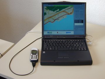
The MOGID system is a software based localization system enabling intelligent value added services (iVAS) and applications on mobile wireless devices, such as GSM cellular telephones. MOGID requires a cellular phone or only module that supports the AT commands and delivers the information available in the AT command to the PDA or WAP level. The basic components are:
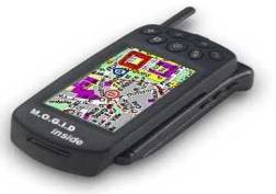
Today any PDA (i.g. palm, Psion, ...) or Laptop, WAP cellular phone or GSM communicator can be used for MOGID. Because it is a software based localization system using available standard GSM Network information, any specific solution can be implemented. It is like the Dolby System or the Intel Inside label. Any portable device can be upgraded to MOGID and this unique feature makes the difference.
Today's 9.6 kb/s already allows to download small city maps of the size of 4 x 4 km at a reasonable speed in less than 5 seconds to the existing MOGID system. In the future, using GPRS the bandwidth is increasing, one could download even some short video clips or music sequences and provide new services on demand.
Compared to the typical wire line data networks available to corporate desktop users, wireless networks are more expensive, provide less bandwidth, with higher latency and less reliability. SMS data service on GSM networks provides 22 bytes (!) per second to a typical mobile host.
The situation is rapidly changing. Emerging packet oriented, cellular networks, such as CDPD and CDMA, and with packet oriented bearer technologies such as GPRS and EDGE are providing higher bandwidth and lower latency. Within the next decade we should see the deployment of "third generation" cellular networks that provide low latency and megabit bandwidth to mobile hosts. But today's wireless networks are slow and tomorrow's wireless networks will be slow compared to tomorrow's wireline networks. Protocols designed for wireline networks without regard for the limitations of wireless networks often exhibit undesirable behavior when deployed on wireless networks. Thus, the wireless value added services target for wireless applications has to make sure to focus on efficient data filtering even before it is transmitted to the user.
Important aspects is bandwidth for data transmission. End 2000 in many European countries GPRS will be available as standard. The available bandwidth on demand and traffic type will definitely allow WAP applications to be very successful for intelligent value added services. This is the birth of a new generation of potential business related to service provider.
WAP cellular phone, or should we call them now I(Ph)ones (Information) instead of Phone (audio signals only), because the voice is not any more the key selling feature, will be available mid 2000. These I(ph)ones are equipped with a WAP or even internet browser. Devices like these will be available on the market and can handle applets and provide graphical information.
It is clear, that a small screen and even more reduced key board will not allow to serve as we are used to do it now. It has to make the "filtering" or "search" accordingly semi or fully automatically. There is the fact to be on the move with such devices and this unique information to be somewhere that we need some information is unique. Thus, the geographical filtering function is already limiting the available information related to the specific location. This will play the major filtering function.
The GSM network inherently provides the ability to localize the mobile device. It became obvious to combine the GSM localization with a filtering function at the input and output of the service provider in order to provide just the content available at the mobile devices surrounding. By the fact that GSM is bi-directional, the user of the mobile device can now easily user dependent select the type if information that is related to the local position or any other local position on demand.
This paper has shown an approach of a software based mobile access technology. It has gained a lot of attention recently. There are strong interests in mobile Web access among a wide range of people and organizations involved in mobile access technology, such as hardware manufacturers, software providers, communication service providers, content providers, and end user organizations.
The MOGID consortium is working towards making information on the World Wide
Web accessible to mobile devices, many of which are characterized by small screens, limited keyboard, low bandwidth connection, small
memory and so on. WAP will play in the next few years a key player role.